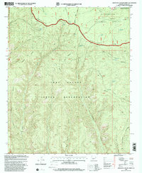
1998 Map of Limestone Canyon North
USGS Topo · Published 2000About this map
The Mogollon Rim forms a dramatic topographical boundary across this portion of Navajo County, separating the high country of the Sitgreaves National Forest from the lands of the Fort Apache Indian Reservation. The area is defined by a series of deep drainages including Limestone Canyon, Jumpoff Canyon, and McCleve Canyon, which cut through the uplifted plateau. Water management in this arid environment is evident through several named tanks and springs, such as Jumpoff Tank, Chino Tank, and Limestone Spring. Human presence is concentrated around the rim and ridges, marked by infrastructure like the Limestone Fire Station and a prominent Lookout. These features, combined with named peaks like Burke Mountain, provide a look at the federal and tribal management of the Arizona landscape during the late twentieth century.
Find a feature on this map
45 named features on this map. Tap any name to fly to it.
Don’t see what you’re looking for? This feature index may not catch every label — zoom into the map to look around manually.
Map Details
Editions of this 1998 Limestone Canyon North Map
This is the sole edition of this map. No revisions or reprints were ever made.
Other maps of this area

1886 · Holbrook
USGS Topo · 1:250,000

1893 · Holbrook
USGS Topo · 1:250,000

1954 · Holbrook
USGS Topo · 1:250,000

1957 · Holbrook
USGS Topo · 1:250,000

1958 · Holbrook
USGS Topo · 1:250,000

1960 · Holbrook
USGS Topo · 1:250,000

1961 · Clay Springs
USGS Topo · 1:62,500
1961 · Show Low
USGS Topo · 1:62,500

1961 · Cibecue
USGS Topo · 1:62,500
1970 · Pinedale
USGS Topo · 1:24,000