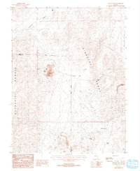
1988 Map of Lincoln Flat
USGS Topo · Published 1993About this map
The Singatse Range and the Buckskin Range dominate this Nevada landscape, meeting at the namesake Lincoln Flat. This 1988 provisional survey documents a high-desert environment shaped by mineral exploration and water scarcity. Resource extraction is evident throughout the terrain, centered on industrial sites like the Minnesota Mine, the Guild Placer Mines, and the Martha Washington Shafts.
Find a feature on this map
19 named features on this map. Tap any name to fly to it.
Don’t see what you’re looking for? This feature index may not catch every label — zoom into the map to look around manually.
Map Details
Editions of this 1988 Lincoln Flat Map
2 editions found
Other maps of this area

1891 · Wabuska
USGS Topo · 1:125,000

1891 · Wellington
USGS Topo · 1:125,000

1893 · Wellington
USGS Topo · 1:125,000

1894 · Wabuska
USGS Topo · 1:125,000

1948 · Walker Lake
USGS Topo · 1:250,000

1957 · Walker Lake
USGS Topo · 1:250,000

1957 · Wellington
USGS Topo · 1:62,500

1957 · Como
USGS Topo · 1:62,500

1957 · Wabuska
USGS Topo · 1:62,500

1957 · Yerington
USGS Topo · 1:62,500