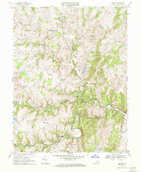
1970 Map of Lincoln
USGS Topo · Published 1972About this map
Lincoln stands as a central settlement in this Piedmont landscape, surrounded by a network of rural hamlets and small crossroads communities. This 1970 field-checked survey reveals a territory defined by the winding course of Goose Creek and its many tributaries, including Beaverdam Creek and Crooked Run. The map provides significant detail for local historians, documenting specific structures such as Mt Olivet Ch and Zion Ch, as well as Camp Highroad near the banks of the North Fork Goose Creek. To the east, the historic grounds of Oatlands are situated near the confluence of local streams and the Telephone line corridor. The terrain is marked by distinct elevations like Vesper Hill and Mount Gilead, while smaller settlements like Philomont, Mountville, and Silcott Spring are linked by a dense web of light-duty and unimproved roads, reflecting the agricultural character of Loudoun County before the onset of modern suburban expansion.
Find a feature on this map
25 named features on this map. Tap any name to fly to it.
Don’t see what you’re looking for? This feature index may not catch every label — zoom into the map to look around manually.
Map Details
Editions of this 1970 Lincoln Map
2 editions found
Other maps of this area

1884 · Harpers Ferry
USGS Topo · 1:125,000

1891 · Harpers Ferry
USGS Topo · 1:125,000

1893 · Harpers Ferry
USGS Topo · 1:125,000

1894 · Warrenton
USGS Topo · 1:125,000

1916 · Berryville
USGS Topo · 1:62,500

1933 · Middleburg
USGS Topo · 1:62,500

1939 · Berryville
USGS Topo · 1:48,000

1943 · Arcola
USGS Topo · 1:24,000

1943 · Bluemont
USGS Topo · 1:24,000

1943 · Rectortown
USGS Topo · 1:24,000