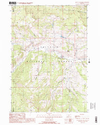
1988 Map of Lincoln Mountain
USGS Topo · Published 1989About this map
Gallatin National Forest dominates this mountain landscape in late 20th-century Montana, where the headwaters of numerous creeks carve through the high terrain. The prominence of Lincoln Mountain overlooks a network of watercourses including Cinnamon Creek and Taylor Creek. Human presence is concentrated around the Nine Quarter Circle Ranch, which features a designated Landing Strip for remote access. To the south, the Wapiti FS Station serves as a key administrative marker for forestry management near the confluence of Wapiti Creek and Little Wapiti Creek. This survey also documents the county boundary separating Madison Co and Gallatin Co, providing a clear record of administrative and topographic features before further modern development.
Find a feature on this map
19 named features on this map. Tap any name to fly to it.
Don’t see what you’re looking for? This feature index may not catch every label — zoom into the map to look around manually.
Map Details
Editions of this 1988 Lincoln Mountain Map
2 editions found
Other maps of this area

1888 · Three Forks
USGS Topo · 1:250,000

1894 · Three Forks
USGS Topo · 1:250,000

1895 · Three Forks
USGS Topo · 1:250,000

1947 · Bozeman
USGS Topo · 1:250,000

1948 · Bozeman
USGS Topo · 1:250,000

1950 · Hebgen Dam
USGS Topo · 1:62,500

1950 · Sphinx Mountain
USGS Topo · 1:62,500

1955 · Bozeman
USGS Topo · 1:250,000

1955 · Crown Butte
USGS Topo · 1:62,500

1955 · Ashton
USGS Topo · 1:250,000