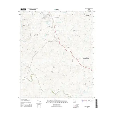
2014 Map of Lincoln Park
USGS Topo · Published 2014About this map
The Flint River forms the winding southern boundary of this Georgia landscape, punctuated by the Snipes Shoals and the crossing of the Chris Collier Bridge. Just south of Thomaston, the community of Lincoln Park is situated along streets named for local figures and landmarks, such as Martin Luther King Dr and Walton St. This area reflects a deep-rooted local history, preserved in its rural crossroads like Redbone Crossroads and Birdsong Crossroads.
Find a feature on this map
76 named features on this map. Tap any name to fly to it.
Don’t see what you’re looking for? This feature index may not catch every label — zoom into the map to look around manually.
Map Details
Editions of this 2014 Lincoln Park Map
This is the sole edition of this map. No revisions or reprints were ever made.
Other maps of this area

1935 · Thomaston
USGS Topo · 1:48,000

1939 · Thomaston
USGS Topo · 1:62,500

1951 · Yatesville
USGS Topo · 1:62,500

1955 · Phenix City
USGS Topo · 1:250,000

1957 · Phenix City
USGS Topo · 1:250,000

1958 · Phenix City
USGS Topo · 1:250,000
1971 · Sunset Village
USGS Topo · 1:24,000
1971 · Roland
USGS Topo · 1:24,000

1971 · Prattsburg
USGS Topo · 1:24,000
1971 · Baldwinville
USGS Topo · 1:24,000