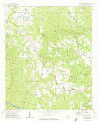
1971 Map of Sunset Village
USGS Topo · Published 1973About this map
Sunset Village and the surrounding rural landscape in Upson County reflect a mid-century period of agriculture and light industry. The map illustrates a transition from traditional farming toward specialized operations, evidenced by the Mccrary Minnow Farm near the McCrary Settlement and the King Mountain Fish Hatchery to the northeast. Historical transit corridors like the Old Alabama Road and Burkets Grade Road navigate a terrain defined by high points such as Salter Mountain and Van Houten Mountain. Community life centers on small gathering points like Ellerbeetown and Crest, where the Crest Lookout Tower stands as a prominent landmark. Educational and spiritual needs are marked by the Thurston Sch and numerous country churches, including Hebron Church and Smyrna Ch. Along the southern boundary, the Flint River flows past Pasley Shoals, anchoring the drainage for local creeks like Turkey Creek.
Find a feature on this map
70 named features on this map. Tap any name to fly to it.
Don’t see what you’re looking for? This feature index may not catch every label — zoom into the map to look around manually.
Map Details
Editions of this 1971 Sunset Village Map
2 editions found
Other maps of this area

1907 · Talbotton
USGS Topo · 1:125,000

1934 · Warm Springs
USGS Topo · 1:62,500

1935 · Thomaston
USGS Topo · 1:48,000

1936 · Warm Springs
USGS Topo · 1:62,500

1939 · Thomaston
USGS Topo · 1:62,500

1953 · Atlanta
USGS Topo · 1:250,000

1955 · Phenix City
USGS Topo · 1:250,000

1957 · Phenix City
USGS Topo · 1:250,000

1957 · Atlanta
USGS Topo · 1:250,000

1958 · Phenix City
USGS Topo · 1:250,000