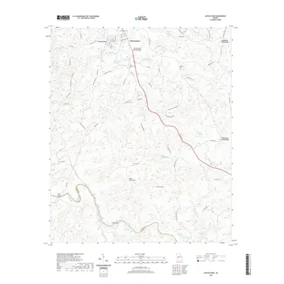
2020 Map of Lincoln Park
USGS Topo · Published 2020About this map
Thomaston and the adjacent settlement of Lincoln Park anchor this Central Georgia landscape, where suburban expansion meets the deeply etched drainage basins of the Piedmont. The topography is defined by the winding course of the Flint River, which forms the southwestern boundary between Upson Co and Talbot Co. Along this corridor, historical landmarks like Snipes Shoals and Snipes Grave Rock offer specific points of interest for local historians, while the presence of the Southern Crescent Technical College Flint River Campus reflects the modern educational infrastructure of the region.
Find a feature on this map
82 named features on this map. Tap any name to fly to it.
Don’t see what you’re looking for? This feature index may not catch every label — zoom into the map to look around manually.
Map Details
Editions of this 2020 Lincoln Park Map
This is the sole edition of this map. No revisions or reprints were ever made.
Other maps of this area

1935 · Thomaston
USGS Topo · 1:48,000

1939 · Thomaston
USGS Topo · 1:62,500

1951 · Yatesville
USGS Topo · 1:62,500

1955 · Phenix City
USGS Topo · 1:250,000

1957 · Phenix City
USGS Topo · 1:250,000

1958 · Phenix City
USGS Topo · 1:250,000
1971 · Sunset Village
USGS Topo · 1:24,000
1971 · Roland
USGS Topo · 1:24,000

1971 · Prattsburg
USGS Topo · 1:24,000
1971 · Baldwinville
USGS Topo · 1:24,000