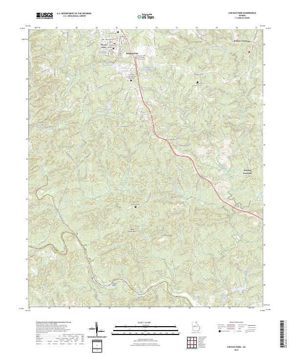
2024 Map of Lincoln Park
USGS Topo · Published 2024About this map
The southern outskirts of Thomaston and the community of Lincoln Park define this Georgia landscape, where the plateaus of Upson County drop toward the Flint River. This modern survey illustrates a transition from the urban street grid of Lincoln Park, home to Lincoln Memorial Cem and Southern Crescent Technical College Flint River Campus, to a more rural topography marked by creeks and named landmarks. To the east and south, the terrain is characterized by dispersed settlements like Redbone Crossroads and Birdsong Crossroads. Historical local lineage is traced through several country burial grounds, including Good Hope Cem and New Harmony Cem. Natural features such as Ten Acre Rock and Snipes Grave Rock provide distinct geographic anchors in the wooded drainage basins of Potato Creek and Swift Creek.
Find a feature on this map
74 named features on this map. Tap any name to fly to it.
Don’t see what you’re looking for? This feature index may not catch every label — zoom into the map to look around manually.
Map Details
Editions of this 2024 Lincoln Park Map
This is the sole edition of this map. No revisions or reprints were ever made.
Other maps of this area

1935 · Thomaston
USGS Topo · 1:48,000

1939 · Thomaston
USGS Topo · 1:62,500

1951 · Yatesville
USGS Topo · 1:62,500

1955 · Phenix City
USGS Topo · 1:250,000

1957 · Phenix City
USGS Topo · 1:250,000

1958 · Phenix City
USGS Topo · 1:250,000
1971 · Sunset Village
USGS Topo · 1:24,000
1971 · Roland
USGS Topo · 1:24,000

1971 · Prattsburg
USGS Topo · 1:24,000
1971 · Baldwinville
USGS Topo · 1:24,000