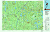
1985 Map of Lincoln
USGS Topo · Published 1994About this map
The Penobscot River serves as the central artery for this region of Penobscot County, where the Maine Central RR and Canadian Pacific RR facilitate trade across the timber-heavy interior. Significant riverfront settlements like Lincoln and Howland are established at key confluences, including where the Piscataquis River and Mattawamkeag River join the Penobscot. Further south, the State Nursery and smaller hamlets such as Olamon and Passadumkeag line the river valley, while the eastern landscape transitions into a vast system of lakes and ridges.
Find a feature on this map
251 named features on this map. Tap any name to fly to it.
Don’t see what you’re looking for? This feature index may not catch every label — zoom into the map to look around manually.
Map Details
Editions of this 1985 Lincoln Map
This is the sole edition of this map. No revisions or reprints were ever made.
Other maps of this area

1902 · Orono
USGS Topo · 1:62,500

1902 · Bangor
USGS Topo · 1:62,500

1917 · Passadumkeag
USGS Topo · 1:62,500

1920 · Winn
USGS Topo · 1:62,500

1929 · Great Pond
USGS Topo · 1:48,000

1929 · Lead Mountain
USGS Topo · 1:48,000

1931 · Springfield
USGS Topo · 1:48,000

1931 · Stetson
USGS Topo · 1:48,000

1931 · Saponac
USGS Topo · 1:48,000

1932 · Dover-Foxcroft
USGS Topo · 1:48,000