1953 Map of Lincoln
USGS Topo · Published 1959About this map
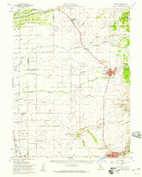
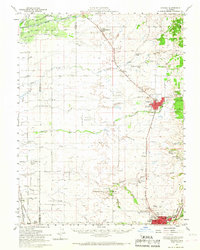
The agricultural and industrial character of the Placer and Sutter County border is clearly visible in this mid-century survey. Lincoln serves as a central hub, flanked by extensive Clay Pit operations and Dredge Tailings that indicate the area's extraction history. To the north, the Bear River and Yankee Slough define the drainage of the Rancho Johnson Grant, while the south is anchored by the growing footprint of Roseville, featuring the Sierra View Country Club and the County Fairgrounds.
Find a feature on this map
57 named features on this map. Tap any name to fly to it.
Don’t see what you’re looking for? This feature index may not catch every label — zoom into the map to look around manually.
Map Details
Editions of this 1953 Lincoln Map
2 editions found
Other maps of this area

1888 · Marysville
USGS Topo · 1:125,000

1888 · Smartsville
USGS Topo · 1:125,000

1891 · Sacramento
USGS Topo · 1:125,000

1891 · Marysville
USGS Topo · 1:125,000

1891 · Smartsville
USGS Topo · 1:125,000

1892 · Sacramento
USGS Topo · 1:125,000

1892 · Smartsville
USGS Topo · 1:125,000

1893 · Sacramento
USGS Topo · 1:125,000

1894 · Smartsville
USGS Topo · 1:125,000

1894 · Marysville
USGS Topo · 1:125,000