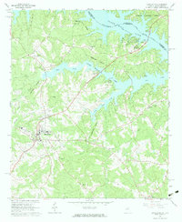
1964 Map of Lincolnton
USGS Topo · Published 1983About this map
Lincolnton serves as the hub of this mid-1960s landscape, where the town’s street grid meets the winding tributaries of the Savannah River. The map documents a period of significant recreational development following the creation of the reservoir, highlighted by the sprawling shoreline of Clark Hill Lake and the establishment of Elijah Clark State Park. This interface between established town life and the new aquatic landscape is evident in landmarks like the Soap Creek Lodge and several boat ramps that began to dot the coves of Soap Creek.
Find a feature on this map
35 named features on this map. Tap any name to fly to it.
Don’t see what you’re looking for? This feature index may not catch every label — zoom into the map to look around manually.
Map Details
Editions of this 1964 Lincolnton Map
2 editions found
Other maps of this area

1892 · Mc Cormick
USGS Topo · 1:125,000

1906 · Crawfordville
USGS Topo · 1:125,000

1912 · Mc Cormick
USGS Topo · 1:125,000

1921 · Appling
USGS Topo · 1:62,500

1943 · Appling
USGS Topo · 1:62,500

1953 · Athens
USGS Topo · 1:250,000

1954 · Metasville
USGS Topo · 1:24,000

1955 · Chennault
USGS Topo · 1:24,000

1958 · Athens
USGS Topo · 1:250,000

1959 · Athens
USGS Topo · 1:250,000