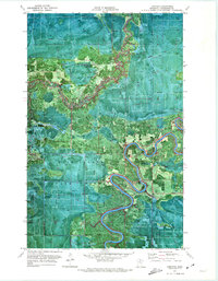
1970 Map of Lindford
USGS Topo · Published 1973About this map
Lindford lies at the heart of this 1970 orthophotomap, situated along the winding oxbows of the Big Fork River. This specialized map combines aerial photography with topographic data, revealing the dense texture of the Pine Island State Forest and Koochiching State Forest. The landscape is defined by the heavy presence of seasonal infrastructure, such as the numerous routes marked simply as Winter Trail, reflecting a wilderness economy reliant on frozen ground for access and timber transport. Along the Black River and its nearby tributaries, scattered activity is evidenced by several Gravel Pits and the isolated Northern Light Gospel Mission. The orthophoto format provides a unique view of the transition between the dark timber of the bogs and the cleared openings of the small river settlements.
Find a feature on this map
10 named features on this map. Tap any name to fly to it.
Don’t see what you’re looking for? This feature index may not catch every label — zoom into the map to look around manually.
Map Details
Editions of this 1970 Lindford Map
This is the sole edition of this map. No revisions or reprints were ever made.
Other maps of this area

1919 · Pelland
USGS Topo · 1:62,500

1919 · Happy Land
USGS Topo · 1:62,500

1943 · Lindford
USGS Topo · 1:62,500

1954 · International Falls
USGS Topo · 1:250,000

1957 · International Falls
USGS Topo · 1:250,000

1958 · International Falls
USGS Topo · 1:250,000

1970 · Devlin
USGS Topo · 1:24,000

1970 · Littlefork SW
USGS Topo · 1:24,000
1970 · Lindford SW
USGS Topo · 1:24,000
1970 · Manitou
USGS Topo · 1:24,000