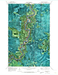
1970 Map of Lindford SE
USGS Topo · Published 1973About this map
The Littlefork River winds in a tight, serpentine pattern through the northern Minnesota wilderness, dominating the center of this orthophotomap. The landscape is primarily defined by the dense timber of the Pine Island State Forest, where the terrain's transition from wetlands to upland forest is clearly visible through the aerial imagery. Human presence is sparse, marked primarily by the seasonal Winter Trail network that cuts through the woods, essential for navigation in this saturated environment. Along the river's edge, Hendrickson Landing stands as a rare identified point of access, reflecting the region's historical reliance on waterways for movement through the Koochiching Co backcountry. This 1970 snapshot records the area just as aerial photogrammetric methods were beginning to provide a new level of visual detail for managing remote state forest lands.
Find a feature on this map
5 named features on this map. Tap any name to fly to it.
Don’t see what you’re looking for? This feature index may not catch every label — zoom into the map to look around manually.
Map Details
Editions of this 1970 Lindford SE Map
This is the sole edition of this map. No revisions or reprints were ever made.
Other maps of this area

1919 · Happy Land
USGS Topo · 1:62,500

1919 · M
USGS Topo · 1:62,500

1919 · Margie
USGS Topo · 1:62,500

1943 · Lindford
USGS Topo · 1:62,500

1954 · International Falls
USGS Topo · 1:250,000

1957 · International Falls
USGS Topo · 1:250,000

1958 · International Falls
USGS Topo · 1:250,000

1970 · Littlefork SW
USGS Topo · 1:24,000
1970 · Lindford SW
USGS Topo · 1:24,000
1970 · Lindford
USGS Topo · 1:24,000