
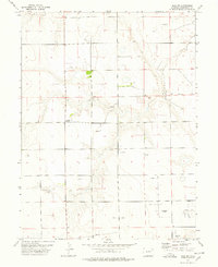
1973 Map of Lindon NE
USGS Topo · Published 1976About this map
Lindon Oil Field dominates the northwest corner of this 1970s landscape in Washington County, marking a period of industrial energy development on the High Plains. The terrain is defined by a series of north-south ridges and draws, with drainage provided by the meandering path of Gordon Creek in the south. Unlike many mountain or coastal sheets, this area is characterized by its sparse settlement and the infrastructure of the petroleum industry, including numerous individual Oil Well sites and a prominent east-west Pipeline that cuts across the northern township line. This map provides a detailed view of the section lines and surveyors' grids that organized the Colorado plains during the mid-20th century, revealing how the land was partitioned for both resource extraction and cattle ranching.
Find a feature on this map
9 named features on this map. Tap any name to fly to it.
Don’t see what you’re looking for? This feature index may not catch every label — zoom into the map to look around manually.
Map Details
Editions of this 1973 Lindon NE Map
This is the sole edition of this map. No revisions or reprints were ever made.
Other maps of this area

1954 · Limon
USGS Topo · 1:250,000

1957 · Limon
USGS Topo · 1:250,000

1958 · Limon
USGS Topo · 1:250,000

1973 · Dry Gulch
USGS Topo · 1:24,000

1973 · Antelope Creek SE
USGS Topo · 1:24,000

1973 · Lindon SW
USGS Topo · 1:24,000

1973 · Lindon
USGS Topo · 1:24,000

1973 · Shaw
USGS Topo · 1:24,000

1977 · Thurman
USGS Topo · 1:24,000
1977 · Elba SW
USGS Topo · 1:24,000