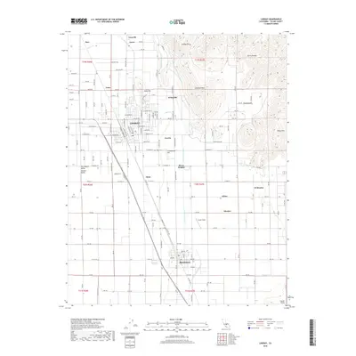
2018 Map of Lindsay
USGS Topo · Published 2018About this map
The Lindsay and Strathmore corridor in the San Joaquin Valley is defined by an intricate network of water management systems critical to the region's agricultural identity. The Friant-Kern Canal and the Lindsay-Strathmore Irrigation Ditch cut through the landscape, supporting a series of small settlements and neighborhood clusters including Tonyville, Fayette, and Sierra Heights. The terrain transitions abruptly from the flat valley floor toward the eastern foothills of the Sierra Nevada, marked by distinctive features such as Elephant Back and the Rocky Hills. This 2018 survey detail provides a modern look at the spatial relationship between these older established towns and the vital irrigation infrastructure. For those researching local family history, the map identifies landmarks like Olive Cem, the Eckert Field airstrip, and several smaller named localities such as Gillette, Mirador, and Todds Hill.
Find a feature on this map
84 named features on this map. Tap any name to fly to it.
Don’t see what you’re looking for? This feature index may not catch every label — zoom into the map to look around manually.
Map Details
Editions of this 2018 Lindsay Map
This is the sole edition of this map. No revisions or reprints were ever made.
Other maps of this area

1904 · Kaweah
USGS Topo · 1:125,000

1909 · Kaweah
USGS Topo · 1:125,000

1925 · Rocky Hill
USGS Topo · 1:31,680

1926 · Exeter
USGS Topo · 1:31,680

1927 · Cairns Corner
USGS Topo · 1:31,680

1927 · Rocky Hill
USGS Topo · 1:31,680

1928 · Woodville
USGS Topo · 1:31,680

1928 · Lindsay
USGS Topo · 1:31,680

1929 · Porterville
USGS Topo · 1:31,680

1937 · Kaweah
USGS Topo · 1:125,000