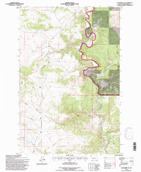
1995 Map of Lingshire NE
USGS Topo · Published 1997About this map
The Smith River carves a dramatic, winding path through this portion of Meagher County, defining a landscape dominated by the Lewis and Clark National Forest. This 1995 revision, based on earlier mid-century aerial photography, shows a wilderness primarily managed by the Kings Hill Ranger District. The terrain is marked by steep elevation changes and named geographical features like Sunset Cliff and the deep incision of Canyon Depth.
Find a feature on this map
21 named features on this map. Tap any name to fly to it.
Don’t see what you’re looking for? This feature index may not catch every label — zoom into the map to look around manually.
Map Details
Editions of this 1995 Lingshire NE Map
This is the sole edition of this map. No revisions or reprints were ever made.
Other maps of this area

1886 · Great Falls
USGS Topo · 1:250,000

1886 · Fort Logan
USGS Topo · 1:250,000

1948 · White Sulphur Springs
USGS Topo · 1:250,000

1954 · Great Falls
USGS Topo · 1:250,000

1957 · Great Falls
USGS Topo · 1:250,000

1958 · White Sulphur Springs
USGS Topo · 1:250,000

1961 · White Sulphur Springs
USGS Topo · 1:250,000

1965 · White Sulphur Springs
USGS Topo · 1:250,000

1966 · Lingshire
USGS Topo · 1:24,000

1966 · Lingshire NE
USGS Topo · 1:24,000