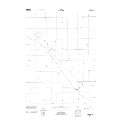
2013 Map of Linn Grove
USGS Topo · Published 2013About this map
The Wabash River carves a diagonal path through this Wells County landscape, anchoring the historic river settlements of Vera Cruz and Linn Grove. In the northern reach, Riverside sits near the river's bend, while Kunkel Lake and Meyer Lakes break the uniform grid of agricultural tracts. The map reveals an intricate network of drainage systems essential to this region's farming heritage, including the Breiner Joint Ditch, Hierly Ditch, and Moser Ditch. Numerous family-run agricultural operations are identified by name, such as Tri Oaks Farm, Solid Rock Farms, and the S and G Poultry Farm. This 2013 survey provides a clear view of the area's transition from riparian woods along Sixmile Cr and Threemile Cr to the expansive, ditch-drained fields that define the modern rural economy of Indiana's eastern borderlands.
Find a feature on this map
54 named features on this map. Tap any name to fly to it.
Don’t see what you’re looking for? This feature index may not catch every label — zoom into the map to look around manually.
Map Details
Editions of this 2013 Linn Grove Map
This is the sole edition of this map. No revisions or reprints were ever made.
Other maps of this area

1911 · Berne
USGS Topo · 1:48,000

1953 · Muncie
USGS Topo · 1:250,000

1956 · Muncie
USGS Topo · 1:250,000

1962 · Uniondale
USGS Topo · 1:24,000

1962 · Preble
USGS Topo · 1:24,000

1962 · Berne
USGS Topo · 1:24,000

1962 · Petroleum
USGS Topo · 1:24,000
1962 · Decatur
USGS Topo · 1:24,000

1962 · Linn Grove
USGS Topo · 1:24,000
1962 · Geneva
USGS Topo · 1:24,000