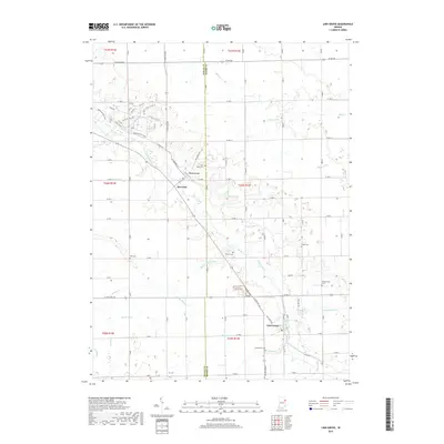
2019 Map of Linn Grove
USGS Topo · Published 2019About this map
The Wabash River meanders diagonally through this section of East Central Indiana, defining the development of small river-oriented communities. Linn Grove serves as a primary southern hub, situated where the river intersects multiple drainage ways like Threemile Cr and Rice Ditch. Further north, Vera Cruz and Riverside sit near the river's bend, surrounded by a complex system of agricultural drainage ditches including Moser Ditch, Markley Ditch, and Breiner Joint Ditch.
Find a feature on this map
66 named features on this map. Tap any name to fly to it.
Don’t see what you’re looking for? This feature index may not catch every label — zoom into the map to look around manually.
Map Details
Editions of this 2019 Linn Grove Map
This is the sole edition of this map. No revisions or reprints were ever made.
Other maps of this area

1911 · Berne
USGS Topo · 1:48,000

1953 · Muncie
USGS Topo · 1:250,000

1956 · Muncie
USGS Topo · 1:250,000

1962 · Uniondale
USGS Topo · 1:24,000

1962 · Preble
USGS Topo · 1:24,000

1962 · Berne
USGS Topo · 1:24,000

1962 · Petroleum
USGS Topo · 1:24,000
1962 · Decatur
USGS Topo · 1:24,000

1962 · Linn Grove
USGS Topo · 1:24,000
1962 · Geneva
USGS Topo · 1:24,000