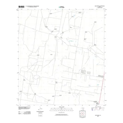
2010 Map of Linn Siding
USGS Topo · Published 2010About this map
Tijerina Ranch and Santa Anita Ranch anchor this South Texas landscape, where life revolves around the scattered water sources and family tracts of the ranching corridor. This 2010 survey of the area near Los Angeles highlights the essential infrastructure of the semi-arid brushland, notably the many named windmills such as Agua Salada Windmill and Santo Domingo Windmill. These features indicate historical property divisions and the vital role of groundwater for cattle operations. The presence of the Santa Anita Cemetery and residential clusters like Lane Number 1 Colonia and Lane Number 2 Colonia reveal the localized settlement patterns that persist along the region’s farm roads. Energy interests are also evident via the Santillana Gas Field, which shares the terrain with traditional agricultural landmarks like Casa Blanca Ranch and El Desierto Ranch.
Find a feature on this map
32 named features on this map. Tap any name to fly to it.
Don’t see what you’re looking for? This feature index may not catch every label — zoom into the map to look around manually.
Map Details
Editions of this 2010 Linn Siding Map
This is the sole edition of this map. No revisions or reprints were ever made.
Other maps of this area

1939 · Linn
USGS Topo · 1:62,500

1939 · La Reforma
USGS Topo · 1:62,500

1940 · Monte Christo
USGS Topo · 1:62,500

1949 · Mc Allen
USGS Topo · 1:250,000

1954 · McAllen
USGS Topo · 1:250,000

1957 · Mc Allen
USGS Topo · 1:250,000

1962 · McAllen
USGS Topo · 1:250,000

1963 · Monte Christo
USGS Topo · 1:24,000
1963 · Hargill
USGS Topo · 1:24,000

1963 · Linn NW
USGS Topo · 1:24,000