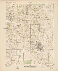
1940 Map of Linton
USGS Topo · Published 1940About this map
Linton serves as the commercial and rail hub of this 1938 survey, revealing a landscape deeply marked by industrial extraction. Numerous areas labeled Strip Mine dominate the outskirts, particularly near Sponsler and Midland, while a dense network of major railroads like the Pennsylvania and Illinois Central connect these worksites to the larger region. The community infrastructure of western Stockton township is well-documented, featuring rural landmarks such as Embury Ch, Olive Branch Ch, and several local schools like Sassafras Sch and Atlas Sch.
Find a feature on this map
44 named features on this map. Tap any name to fly to it.
Don’t see what you’re looking for? This feature index may not catch every label — zoom into the map to look around manually.
Map Details
Editions of this 1940 Linton Map
2 editions found
Other maps of this area

1938 · Coal City
USGS Topo · 1:24,000

1938 · Switz City
USGS Topo · 1:24,000

1940 · Linton
USGS Topo · 1:24,000

1940 · Jasonville
USGS Topo · 1:24,000

1943 · Lyons
USGS Topo · 1:24,000

1943 · Hymera
USGS Topo · 1:24,000

1943 · Sandborn
USGS Topo · 1:24,000

1943 · Dugger
USGS Topo · 1:24,000

1944 · Bucktown
USGS Topo · 1:24,000

1947 · Switz City
USGS Topo · 1:24,000