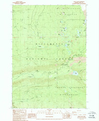
1988 Map of Linton Lake
USGS Topo · Published 1988About this map
Mt Washington Wilderness and Three Sisters Wilderness converge in this high-elevation landscape of the Willamette National Forest. This late-1980s data highlights a region defined by dramatic hydrology and volcanic geology, featuring numerous high-country water bodies like Scott Lake and Linton Lake, as well as prominent cascades including Proxy Falls and Linton Falls. The map reveals the imprint of mid-century forestry and recreation, noting sites like Knobs Sheep Camp, Hand Lake Shelter, and the White Branch Youth Camp. Geologic markers are distinct throughout, from the Lava Lake Valley to several quarries and a Borrow Pit, while ridges such as Proxy Ridge and peaks like Scott Mtn dictate the drainage of Boulder Creek and its tributaries. This provisional survey provides a snapshot of the infrastructure supporting backcountry travel and forest management just before the turn of the millennium.
Find a feature on this map
50 named features on this map. Tap any name to fly to it.
Don’t see what you’re looking for? This feature index may not catch every label — zoom into the map to look around manually.
Map Details
Editions of this 1988 Linton Lake Map
This is the sole edition of this map. No revisions or reprints were ever made.
Other maps of this area

1929 · Three Sisters
USGS Topo · 1:125,000

1932 · Three Sisters
USGS Topo · 1:125,000

1934 · Mc Kenzie Bridge
USGS Topo · 1:96,000

1940 · Mc Kenzie Bridge
USGS Topo · 1:125,000

1953 · Salem
USGS Topo · 1:250,000

1954 · Salem
USGS Topo · 1:250,000

1955 · Echo Mountain
USGS Topo · 1:62,500

1955 · Mc Kenzie Bridge
USGS Topo · 1:62,500

1955 · Bend
USGS Topo · 1:250,000

1957 · Bend
USGS Topo · 1:250,000