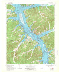
1967 Map of Linton
USGS Topo · Published 1970About this map
Lake Barkley and the Cumberland River dominate this landscape during a period of significant regional transformation, straddling the border between Trigg County and Stewart County. The western portion of the map covers the expansive Land Between the Lakes, a protected area defined by its intricate network of drainage systems like Pryor Creek and Terrapin Creek. The survey documents the area shortly after the completion of the Barkley Dam, showing newly formed recreational and conservation zones such as the Waterfowl Management Area and the Donaldson Creek Public Use Area. Small settlements like Linton, Model, and Tobaccoport remain as anchors of local history, while numerous unnamed cemeteries and family-named landmarks like Big Joe Spring and Fox Ridge provide critical data for genealogical research. The map illustrates a transition from a river-dependent agricultural economy to one focused on large-scale water management and federal recreation.
Find a feature on this map
41 named features on this map. Tap any name to fly to it.
Don’t see what you’re looking for? This feature index may not catch every label — zoom into the map to look around manually.
Map Details
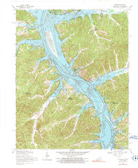
Editions of this 1967 Linton Map
2 editions found
Other maps of this area

1936 · Tharpe
USGS Topo · 1:24,000

1936 · Hamlin
USGS Topo · 1:24,000

1936 · Fenton
USGS Topo · 1:24,000

1936 · Golden Pond
USGS Topo · 1:48,000

1936 · Rushing
USGS Topo · 1:24,000

1950 · Rushing Creek
USGS Topo · 1:24,000
1950 · Fenton
USGS Topo · 1:24,000
1950 · Hamlin
USGS Topo · 1:24,000

1951 · Model
USGS Topo · 1:24,000

1951 · Johnson Hollow
USGS Topo · 1:24,000