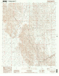
1986 Map of Lion Head Mtn
USGS Topo · Published 1987About this map
Chocolate Mountain dominates this desert landscape within Imperial County, defined largely by the restricted boundaries of the Chocolate Mountain Aerial Gunnery Range. The terrain is characterized by complex desert washes and steep elevations, with Lion Head Mtn serving as a prominent landmark. Settlement is nearly non-existent, represented primarily by the isolated location of Beal Well, a critical water point in this arid environment.
Find a feature on this map
13 named features on this map. Tap any name to fly to it.
Don’t see what you’re looking for? This feature index may not catch every label — zoom into the map to look around manually.
Map Details
Editions of this 1986 Lion Head Mtn Map
3 editions found
Other maps of this area

1940 · Iris
USGS Topo · 1:62,500

1940 · Iris Pass
USGS Topo · 1:62,500

1945 · Iris Pass
USGS Topo · 1:62,500

1945 · Iris
USGS Topo · 1:62,500

1953 · Chuckwalla Spring
USGS Topo · 1:62,500

1953 · Acolita
USGS Topo · 1:62,500

1954 · Salton Sea
USGS Topo · 1:250,000

1955 · Tortuga
USGS Topo · 1:24,000

1955 · Salton Sea
USGS Topo · 1:250,000
1956 · Iris
USGS Topo · 1:24,000