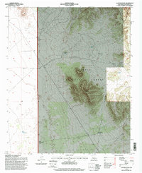
1995 Map of Lion Mountain
USGS Topo · Published 1998About this map
Lion Mountain rises as a prominent landmark within the Cibola National Forest, anchoring a high-desert landscape defined by ranching and resource management. This mid-1990s survey, updated from 1960s data, illustrates the vital role of water infrastructure in Socorro County, with numerous landmarks like the Corral Montosas Deep Well and High Lonesome Well scattered across the basin. The Gallinas Mountains form a significant backdrop to the northeast, while Antelope Flats suggests the open grazing character of the land. Human presence is centered on sites like the Double H Ranch, supported by a network of tanks and windmills such as East Tank and the Three Section Windmill. This map documents a traditional Western landscape where early 20th-century ranching developments remained the primary footprint in the late 1900s.
Find a feature on this map
20 named features on this map. Tap any name to fly to it.
Don’t see what you’re looking for? This feature index may not catch every label — zoom into the map to look around manually.
Map Details
Editions of this 1995 Lion Mountain Map
This is the sole edition of this map. No revisions or reprints were ever made.
Other maps of this area

1954 · Socorro
USGS Topo · 1:250,000

1958 · Socorro
USGS Topo · 1:250,000

1962 · Socorro
USGS Topo · 1:250,000

1964 · Arrowhead Well
USGS Topo · 1:24,000

1964 · Indian Mesa
USGS Topo · 1:24,000

1964 · Tres Montosas
USGS Topo · 1:24,000

1964 · Dog Springs
USGS Topo · 1:24,000

1964 · Gallinas Peak
USGS Topo · 1:24,000

1964 · Lion Mountain
USGS Topo · 1:24,000
1964 · Indian Spring Canyon
USGS Topo · 1:24,000