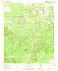
1964 Map of Indian Spring Canyon
USGS Topo · Published 1968About this map
Cibola National Forest encompasses this high desert landscape, where water sources dictated the location of early ranching and mining operations in the 1960s. Scattered family outposts such as Fretoso Ranch, Montoya Ranch, and Chavez Ranch appear near vital water features like Alamo Creek and Chavez Creek. The presence of the Hot Spot Mines suggests early exploration into the mineral potential of the surrounding hills.
Find a feature on this map
35 named features on this map. Tap any name to fly to it.
Don’t see what you’re looking for? This feature index may not catch every label — zoom into the map to look around manually.
Map Details
Editions of this 1964 Indian Spring Canyon Map
This is the sole edition of this map. No revisions or reprints were ever made.
Other maps of this area

1954 · Socorro
USGS Topo · 1:250,000

1958 · Socorro
USGS Topo · 1:250,000

1962 · Socorro
USGS Topo · 1:250,000

1964 · Indian Mesa
USGS Topo · 1:24,000

1964 · La Jara Peak
USGS Topo · 1:24,000

1964 · Table Mountain
USGS Topo · 1:24,000

1964 · Silver Hill
USGS Topo · 1:24,000

1964 · Gallinas Peak
USGS Topo · 1:24,000

1964 · Puertecito
USGS Topo · 1:24,000

1964 · Lion Mountain
USGS Topo · 1:24,000