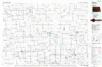
1986 Map of Lisbon
USGS Topo · Published 1986About this map
Lisbon serves as a primary hub in this portion of North Dakota, situated where the Sheyenne River winds through the northern townships. This 1986 planimetric survey captures the region's agricultural and conservation landscape, dominated by a vast network of water management and wildlife protection areas such as the Tewaukon National Wildlife Refuge and the Wild Rice National Wildlife Refuge. The map illustrates a period of transition for the rail-and-river economy, showing the infrastructure of the Burlington Northern, Northern Pacific, and Soo Line railroads connecting grain-elevator towns like Milnor, Wyndmere, and Lidgerwood. Beyond the river valleys, the terrain rises toward the Whitestone Hills, while the landscape is dotted with numerous glacial sloughs and lakes, including Storm Lake and Borg Lake, which define the local drainage patterns and land use in Sargent County and Ransom County.
Find a feature on this map
146 named features on this map. Tap any name to fly to it.
Don’t see what you’re looking for? This feature index may not catch every label — zoom into the map to look around manually.
Map Details
Editions of this 1986 Lisbon Map
2 editions found
Other maps of this area

1894 · Hecla
USGS Topo · 1:62,500

1894 · Oakes
USGS Topo · 1:62,500

1895 · Lamoure
USGS Topo · 1:125,000

1895 · Fargo
USGS Topo · 1:125,000

1895 · Casselton
USGS Topo · 1:125,000

1896 · Columbia
USGS Topo · 1:125,000

1897 · Fargo
USGS Topo · 1:125,000

1897 · Tower
USGS Topo · 1:125,000

1897 · Eckelson
USGS Topo · 1:125,000

1897 · Casselton
USGS Topo · 1:125,000