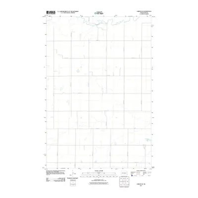
2011 Map of Lisbon SE
USGS Topo · Published 2011About this map
The Sheyenne River meanders across the northern reaches of this landscape, defining the local hydrology within Willey Township. This 2011 survey illustrates a strictly organized agricultural grid, where section lines are maintained by a network of gravel and local roads such as 72nd St SE and 133rd Ave SE. The terrain is punctuated by small prairie potholes and larger water bodies like Hultman Lake in the southeast corner. This map provides a clear record of modern rural infrastructure in Sargent County, showing how the natural drainage of the river corridor interacts with the rigid geometric boundaries of the American West's township and range system.
Find a feature on this map
18 named features on this map. Tap any name to fly to it.
Don’t see what you’re looking for? This feature index may not catch every label — zoom into the map to look around manually.
Map Details
Editions of this 2011 Lisbon SE Map
This is the sole edition of this map. No revisions or reprints were ever made.
Other maps of this area

1907 · Wyndmere
USGS Topo · 1:125,000

1953 · Fargo
USGS Topo · 1:250,000

1956 · Fargo
USGS Topo · 1:250,000

1958 · Cayuga NW
USGS Topo · 1:24,000

1960 · Lisbon SE
USGS Topo · 1:24,000

1960 · Lisbon NE
USGS Topo · 1:24,000

1960 · Venlo
USGS Topo · 1:24,000

1960 · Milnor
USGS Topo · 1:24,000

1962 · Lisbon
USGS Topo · 1:24,000
1962 · Hoving
USGS Topo · 1:24,000
Featured Places
- Willey Township, ND
- Aliceton Township, ND
- Milnor Township, ND
- Big Bend Township, ND
- Scoville Township, ND