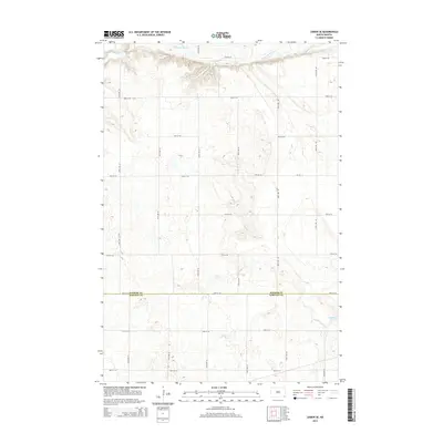
2014 Map of Lisbon SE
USGS Topo · Published 2014About this map
Sheyenne River defines the northern edge of this prairie landscape, carving a prominent valley through the high plains of southeastern North Dakota. The terrain here transitions from the river's riparian corridor to the structured agricultural grid characteristic of Willey Township. The interplay of water and topography is most evident where Dead Colt Cr feeds into the main river system, and near the natural basin of Hultman Lake in the southeast. This 2014 survey documents the enduring sectional road network, including Cr-133 and a series of numbered avenues like 134th Ave SE, that serves the rural farmsteads along the Ransom and Sargent county line. The map illustrates a landscape of high-density contour intervals indicating subtle but significant prairie depressions and rises.
Find a feature on this map
21 named features on this map. Tap any name to fly to it.
Don’t see what you’re looking for? This feature index may not catch every label — zoom into the map to look around manually.
Map Details
Editions of this 2014 Lisbon SE Map
This is the sole edition of this map. No revisions or reprints were ever made.
Other maps of this area

1907 · Wyndmere
USGS Topo · 1:125,000

1953 · Fargo
USGS Topo · 1:250,000

1956 · Fargo
USGS Topo · 1:250,000

1958 · Cayuga NW
USGS Topo · 1:24,000

1960 · Lisbon SE
USGS Topo · 1:24,000

1960 · Lisbon NE
USGS Topo · 1:24,000

1960 · Venlo
USGS Topo · 1:24,000

1960 · Milnor
USGS Topo · 1:24,000

1962 · Lisbon
USGS Topo · 1:24,000
1962 · Hoving
USGS Topo · 1:24,000
Featured Places
- Willey Township, ND
- Aliceton Township, ND
- Milnor Township, ND
- Big Bend Township, ND
- Scoville Township, ND