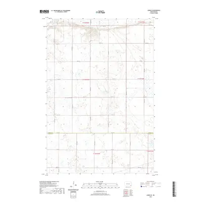
2020 Map of Lisbon SE
USGS Topo · Published 2020About this map
The Sheyenne River winds across the northern edge of this North Dakota landscape, carving a distinct valley through the prairie of the Ransom and Sargent County border. This region is defined by its agricultural grid and scattered water features, including Hultman Lake and the drainage of Dead Colt Creek. For those tracing local heritage, the map identifies key burial sites like the Aliceton Pioneer Cemetery and Zion Cemetery, which anchor the surrounding rural townships. The layout of section lines and range markers, such as t133n r55w, illustrates the systematic land division that has shaped the state's farming economy for generations.
Find a feature on this map
21 named features on this map. Tap any name to fly to it.
Don’t see what you’re looking for? This feature index may not catch every label — zoom into the map to look around manually.
Map Details
Editions of this 2020 Lisbon SE Map
This is the sole edition of this map. No revisions or reprints were ever made.
Other maps of this area

1907 · Wyndmere
USGS Topo · 1:125,000

1953 · Fargo
USGS Topo · 1:250,000

1956 · Fargo
USGS Topo · 1:250,000

1958 · Cayuga NW
USGS Topo · 1:24,000

1960 · Lisbon SE
USGS Topo · 1:24,000

1960 · Lisbon NE
USGS Topo · 1:24,000

1960 · Venlo
USGS Topo · 1:24,000

1960 · Milnor
USGS Topo · 1:24,000

1962 · Lisbon
USGS Topo · 1:24,000
1962 · Hoving
USGS Topo · 1:24,000
Featured Places
- Willey Township, ND
- Aliceton Township, ND
- Milnor Township, ND
- Big Bend Township, ND
- Scoville Township, ND