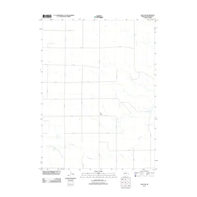
2011 Map of Lisco SW
USGS Topo · Published 2011About this map
Saint Johns Cemetery stands as a primary landmark in this rural section of Cheyenne County, situated at the intersection of several local routes. The landscape is defined by the wandering path of Rush Creek, which cuts through the southern and eastern portions of the quadrangle. This high plains territory is organized by an extensive grid of section-line roads, including Road 52, Road 50, and Road 44, reflecting the geometric precision of Western land division. The map captures the agricultural character of the region early in the twenty-first century, showing a terrain shaped by water drainage patterns and a sparse network of long-distance rural transit routes.
Find a feature on this map
17 named features on this map. Tap any name to fly to it.
Don’t see what you’re looking for? This feature index may not catch every label — zoom into the map to look around manually.
Map Details
Editions of this 2011 Lisco SW Map
This is the sole edition of this map. No revisions or reprints were ever made.
Other maps of this area

1899 · Sidney
USGS Topo · 1:125,000

1954 · Scottsbluff
USGS Topo · 1:250,000

1958 · Scottsbluff
USGS Topo · 1:250,000

1972 · Lisco NW
USGS Topo · 1:24,000
1972 · Fairchild Ranch
USGS Topo · 1:24,000

1972 · Lodgepole
USGS Topo · 1:24,000

1972 · Lisco SW
USGS Topo · 1:24,000
1972 · Lisco SE
USGS Topo · 1:24,000
1972 · Mount Vernon
USGS Topo · 1:24,000

1972 · Sunol
USGS Topo · 1:24,000