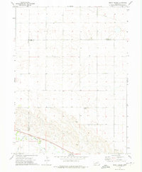
1972 Map of Mount Vernon
USGS Topo · Published 1975About this map
Lodgepole Creek and the Union Pacific railroad corridor define the southern landscape of this Deuel County region in the early 1970s. The map illustrates a transition between the irrigated valley floor and the upland tablelands, where the small settlement of Mount Vernon and the locality of Isley represent the area's sparse population centers. Transportation and infrastructure are central to the geography here, with a Landing Strip and a modern Pipeline cutting across the northern sections, while a Radio Tower stands as a landmark on the eastern edge. Industrial activity is localized near the water, evidenced by a Gravel Pit and the convergence of Cow Cr with the main drainage. This survey provides a clear view of the high plains agricultural layout, including detailed fence and field lines that mark the division of ranching and farming lands during this era.
Find a feature on this map
12 named features on this map. Tap any name to fly to it.
Don’t see what you’re looking for? This feature index may not catch every label — zoom into the map to look around manually.
Map Details
Editions of this 1972 Mount Vernon Map
This is the sole edition of this map. No revisions or reprints were ever made.
Other maps of this area

1899 · Sidney
USGS Topo · 1:125,000

1900 · Chappell
USGS Topo · 1:125,000

1954 · Scottsbluff
USGS Topo · 1:250,000

1958 · Scottsbluff
USGS Topo · 1:250,000

1961 · Chappell
USGS Topo · 1:24,000

1971 · Oshkosh SW
USGS Topo · 1:24,000

1971 · Chappell NW
USGS Topo · 1:24,000

1972 · Lodgepole
USGS Topo · 1:24,000

1972 · Lisco SW
USGS Topo · 1:24,000
1972 · Lodgepole SE
USGS Topo · 1:24,000