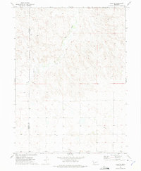
1972 Map of Lisco SE
USGS Topo · Published 1975About this map
Rush Creek carves a winding path through the semi-arid landscape of the Nebraska Panhandle in this early 1970s survey. The terrain is defined by the high-plains topography of Cheyenne and Garden counties, where the land is marked by complex contouring and remote ranching infrastructure. Isolated water sources like the identified Well and the presence of a Pipeline cutting across the southern sections indicate the necessity of water management and modern energy transport in this open country. High points such as Chulik provide navigational landmarks for the region, while a Radio Tower near the southern boundary stands as a rare sign of mid-century technological presence. The map documents a sparsely populated but active agricultural and utility corridor before further modern development altered the rural character of the Panhandle.
Find a feature on this map
7 named features on this map. Tap any name to fly to it.
Don’t see what you’re looking for? This feature index may not catch every label — zoom into the map to look around manually.
Map Details
Editions of this 1972 Lisco SE Map
This is the sole edition of this map. No revisions or reprints were ever made.
Other maps of this area

1899 · Sidney
USGS Topo · 1:125,000

1900 · Chappell
USGS Topo · 1:125,000

1954 · Scottsbluff
USGS Topo · 1:250,000

1958 · Scottsbluff
USGS Topo · 1:250,000

1971 · Oshkosh SW
USGS Topo · 1:24,000

1971 · Coumbe Bluff
USGS Topo · 1:24,000

1971 · Chappell NW
USGS Topo · 1:24,000

1972 · Lisco NW
USGS Topo · 1:24,000

1972 · Lodgepole
USGS Topo · 1:24,000

1972 · Lisco SW
USGS Topo · 1:24,000