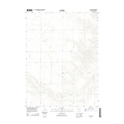
2014 Map of Lisco SW
USGS Topo · Published 2014About this map
Saint Johns Cem stands as a focal point of historical record in this section of Cheyenne County, situated near the intersection of Road 42 and Road 143. The landscape is defined by the winding course of Rush Cr, which carves through the southern terrain, influencing the layout of the local section-line road network. This grid of thoroughfares, including Road 50 and Road 149, illustrates the systematic organization of the Nebraska high plains and provides access to the agricultural parcels that dominate the region. The absence of major urban centers highlights a rural environment where community life centered around local landmarks and the seasonal changes along the creek bed.
Find a feature on this map
16 named features on this map. Tap any name to fly to it.
Don’t see what you’re looking for? This feature index may not catch every label — zoom into the map to look around manually.
Map Details
Editions of this 2014 Lisco SW Map
This is the sole edition of this map. No revisions or reprints were ever made.
Other maps of this area

1899 · Sidney
USGS Topo · 1:125,000

1954 · Scottsbluff
USGS Topo · 1:250,000

1958 · Scottsbluff
USGS Topo · 1:250,000

1972 · Lisco NW
USGS Topo · 1:24,000
1972 · Fairchild Ranch
USGS Topo · 1:24,000

1972 · Lodgepole
USGS Topo · 1:24,000

1972 · Lisco SW
USGS Topo · 1:24,000
1972 · Lisco SE
USGS Topo · 1:24,000
1972 · Mount Vernon
USGS Topo · 1:24,000

1972 · Sunol
USGS Topo · 1:24,000