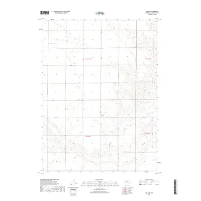
2017 Map of Lisco SW
USGS Topo · Published 2017About this map
Saint Johns Cem, located near the intersection of RD 143 and RD 42, serves as a quiet landmark in this rural landscape of Cheyenne County. The terrain is defined by the winding course of Rush Cr, which meanders through the southern portion of the quadrangle. This 2017 survey reflects the enduring grid of the Public Land Survey System, with township boundaries like t16n r47w and t15n r46w organizing the high plains. The map illustrates a sparse, agricultural infrastructure dominated by a network of county roads such as RD 137, RD 50, and RD 141, showing the modern connectivity required to manage large-scale ranching and farming operations in western Nebraska.
Find a feature on this map
21 named features on this map. Tap any name to fly to it.
Don’t see what you’re looking for? This feature index may not catch every label — zoom into the map to look around manually.
Map Details
Editions of this 2017 Lisco SW Map
This is the sole edition of this map. No revisions or reprints were ever made.
Other maps of this area

1899 · Sidney
USGS Topo · 1:125,000

1954 · Scottsbluff
USGS Topo · 1:250,000

1958 · Scottsbluff
USGS Topo · 1:250,000

1972 · Lisco NW
USGS Topo · 1:24,000
1972 · Fairchild Ranch
USGS Topo · 1:24,000

1972 · Lodgepole
USGS Topo · 1:24,000

1972 · Lisco SW
USGS Topo · 1:24,000
1972 · Lisco SE
USGS Topo · 1:24,000
1972 · Mount Vernon
USGS Topo · 1:24,000

1972 · Sunol
USGS Topo · 1:24,000