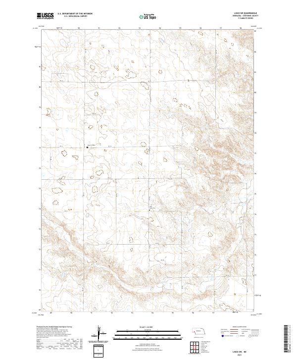
2021 Map of Lisco SW
USGS Topo · Published 2021About this map
Weyerts Cem and Saint Johns Cem stand as the primary cultural landmarks in this rural section of Cheyenne County. The landscape is defined by the drainage of Rush Cr in the southern portion of the quadrangle, with the terrain marked by a series of draws and ridges common to the Nebraska Panhandle. The grid of country roads, including RD 139, RD 143, and RD 46, provides the framework for this high plains agricultural area. The mapping reflects the enduring Township and Range system, specifically sections within T16N R47W and T15N R47W, where the sparse population is centered around these established burial grounds and intermittent watercourses.
Find a feature on this map
22 named features on this map. Tap any name to fly to it.
Don’t see what you’re looking for? This feature index may not catch every label — zoom into the map to look around manually.
Map Details
Editions of this 2021 Lisco SW Map
This is the sole edition of this map. No revisions or reprints were ever made.
Other maps of this area

1899 · Sidney
USGS Topo · 1:125,000

1954 · Scottsbluff
USGS Topo · 1:250,000

1958 · Scottsbluff
USGS Topo · 1:250,000

1972 · Lisco NW
USGS Topo · 1:24,000
1972 · Fairchild Ranch
USGS Topo · 1:24,000

1972 · Lodgepole
USGS Topo · 1:24,000

1972 · Lisco SW
USGS Topo · 1:24,000
1972 · Lisco SE
USGS Topo · 1:24,000
1972 · Mount Vernon
USGS Topo · 1:24,000

1972 · Sunol
USGS Topo · 1:24,000