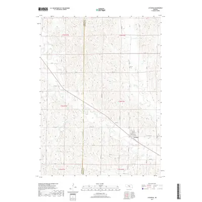
2017 Map of Litchfield
USGS Topo · Published 2017About this map
Litchfield serves as the central hub for this Sherman County landscape, situated along the banks of Mud Cr. The settlement is defined by a traditional grid of streets including E Bufford St, Clifford St, and Gregory St, while the surrounding rural township is characterized by a high density of winding creek beds and drainage draws. To the north and south, the terrain is marked by significant hydrological features such as Clear Cr, Stoddard Cr, and Dutch Cr, which have shaped the agricultural development of the region. Genealogists and local historians will find the locations of Litchfield Cem and the more remote Gray Cem particularly useful for tracing early family plots. The county line between Custer and Sherman runs north-south through the center-west portion of the map, illustrating the administrative boundaries that intersected local homesteads and travel routes like Litchfield Rd.
Find a feature on this map
47 named features on this map. Tap any name to fly to it.
Don’t see what you’re looking for? This feature index may not catch every label — zoom into the map to look around manually.
Map Details
Editions of this 2017 Litchfield Map
This is the sole edition of this map. No revisions or reprints were ever made.
Other maps of this area

1951 · Arcadia SE
USGS Topo · 1:24,000

1951 · Litchfield SW
USGS Topo · 1:24,000

1951 · Litchfield NE
USGS Topo · 1:24,000

1951 · Hazard
USGS Topo · 1:24,000

1951 · Mason City
USGS Topo · 1:24,000

1951 · Ansley SE
USGS Topo · 1:24,000

1951 · Mason City SE
USGS Topo · 1:24,000

1951 · Arcadia SW
USGS Topo · 1:24,000

1951 · Litchfield
USGS Topo · 1:24,000

1955 · Broken Bow
USGS Topo · 1:250,000