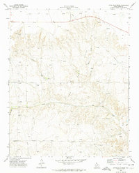
1972 Map of Little Blue Creek
USGS Topo · Published 1974About this map
Gas Field operations and energy infrastructure define this 1970s landscape in Moore County, where an extensive network of Pipeline segments and numerous Pumping Sta locations traverse the drainage basins. The area is characterized by the convergence of several waterways, most notably Big Blue Creek and its tributary Little Blue Creek, which carve through the Panhandle terrain alongside Ludlow Creek and Running Water Cr.
Find a feature on this map
15 named features on this map. Tap any name to fly to it.
Don’t see what you’re looking for? This feature index may not catch every label — zoom into the map to look around manually.
Map Details
Editions of this 1972 Little Blue Creek Map
This is the sole edition of this map. No revisions or reprints were ever made.
Other maps of this area

1936 · Fourways
USGS Topo · 1:62,500

1939 · Sanford
USGS Topo · 1:62,500

1953 · Evans Canyon
USGS Topo · 1:24,000

1953 · Masterson
USGS Topo · 1:24,000

1953 · Spencer Draw
USGS Topo · 1:24,000

1954 · Amarillo
USGS Topo · 1:250,000

1958 · Amarillo
USGS Topo · 1:250,000

1965 · Dumas South
USGS Topo · 1:24,000
1965 · Dumas North
USGS Topo · 1:24,000

1972 · Dumas NE
USGS Topo · 1:24,000