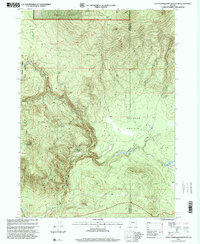
1997 Map of Little Chinquapin Mountain
USGS Topo · Published 2000About this map
Little Chinquapin Mountain and the high-elevation meadows of the Rogue River National Forest define this 1997 topographic survey of the Southern Oregon Cascades. The landscape is marked by a complex network of springs and creeks, including Big Springs, Bluejay Spring, and the headwaters of Jenny Creek, which flow through steep terrain toward Johnson Prairie. Significant for hikers and conservationists, the Pacific Crest National Scenic Trail traverses the western portion of the quadrangle, passing through the Howard Prairie Recreation Area near Grizzly Prairie. The map captures the boundary between Jackson and Klamath Counties, a region dominated by peaks like Brush Mountain and Old Baldy. For researchers, the presence of a Cinder Pit near Tucker Glade points to the local geology and resource extraction history of this timber-rich and volcanic terrain.
Find a feature on this map
24 named features on this map. Tap any name to fly to it.
Don’t see what you’re looking for? This feature index may not catch every label — zoom into the map to look around manually.
Map Details
Editions of this 1997 Little Chinquapin Mountain Map
This is the sole edition of this map. No revisions or reprints were ever made.
Other maps of this area

1891 · Ashland
USGS Topo · 1:250,000

1893 · Ashland
USGS Topo · 1:250,000

1897 · Ashland
USGS Topo · 1:250,000

1955 · Lake O' Woods
USGS Topo · 1:62,500

1955 · Surveyor Mtn
USGS Topo · 1:62,500

1955 · Hyatt Reservoir
USGS Topo · 1:62,500

1955 · Mt. Mc Loughlin
USGS Topo · 1:62,500

1955 · Medford
USGS Topo · 1:250,000

1957 · Medford
USGS Topo · 1:250,000

1958 · Medford
USGS Topo · 1:250,000