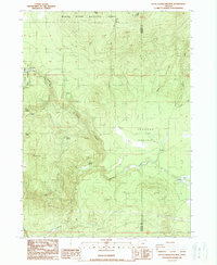
1988 Map of Little Chinquapin Mtn
USGS Topo · Published 1988About this map
The high timberlands and volcanic peaks of the Rogue River National Forest dominate this landscape on the border of Jackson and Klamath counties. The southern reaches of the Pacific Crest National Scenic Trail wind along the western ridges, crossing through the Howard Prairie Recreation Area near Grizzly Prairie. The map captures a transition from the prominent height of Little Chinquapin Mtn down into the high meadow systems of Johnson Prairie. Significant water sources, essential for both the ecology and early resource extraction in the region, are meticulously identified, including Fredenburg Spring, Bluejay Spring, and Big Springs. The presence of the Pinder Pit and the Steel Tower Transmission Line indicates the late-20th-century intersection of public forest management with regional industrial infrastructure and energy corridors.
Find a feature on this map
28 named features on this map. Tap any name to fly to it.
Don’t see what you’re looking for? This feature index may not catch every label — zoom into the map to look around manually.
Map Details
Editions of this 1988 Little Chinquapin Mtn Map
This is the sole edition of this map. No revisions or reprints were ever made.
Other maps of this area

1891 · Ashland
USGS Topo · 1:250,000

1893 · Ashland
USGS Topo · 1:250,000

1897 · Ashland
USGS Topo · 1:250,000

1955 · Lake O' Woods
USGS Topo · 1:62,500

1955 · Surveyor Mtn
USGS Topo · 1:62,500

1955 · Hyatt Reservoir
USGS Topo · 1:62,500

1955 · Mt. Mc Loughlin
USGS Topo · 1:62,500

1955 · Medford
USGS Topo · 1:250,000

1957 · Medford
USGS Topo · 1:250,000

1958 · Medford
USGS Topo · 1:250,000