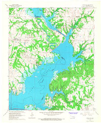
1967 Map of Little City
USGS Topo · Published 1968About this map
Fort Washita stands near the northern reaches of Lake Texoma, marking a landscape where the Washita River meets the expansive reservoir. This mid-century survey illustrates the dramatic engineering required to manage these waters, notably the Cumberland Levee and the Cumberland Cut, which rerouted the river to bypass an extensive Oil Field. These diversions left behind the Old Channel, creating a complex network of wetlands and islands like Goat Island.
Find a feature on this map
29 named features on this map. Tap any name to fly to it.
Don’t see what you’re looking for? This feature index may not catch every label — zoom into the map to look around manually.
Map Details
Editions of this 1967 Little City Map
This is the sole edition of this map. No revisions or reprints were ever made.
Other maps of this area

1899 · Atoka
USGS Topo · 1:125,000

1900 · Atoka
USGS Topo · 1:125,000

1901 · Tishomingo
USGS Topo · 1:125,000

1901 · Denison
USGS Topo · 1:125,000

1954 · Sherman
USGS Topo · 1:250,000

1957 · Ardmore
USGS Topo · 1:250,000

1958 · Durant
USGS Topo · 1:62,500

1958 · Denison Dam
USGS Topo · 1:62,500

1958 · Sherman
USGS Topo · 1:250,000

1963 · Ardmore
USGS Topo · 1:250,000