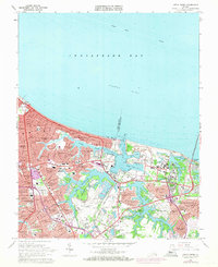
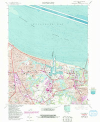
1964 Map of Little Creek
USGS Topo · Published 1971About this map
U S Naval Reservation Little Creek Amphibious Base dominates the shoreline east of East Ocean View, anchoring a landscape defined by its strategic coastal position and mid-century suburban expansion. The survey documents the dense residential development between Chesapeake Bay and the interconnected waters of Lake Whitehurst and Little Creek Reservoir. These freshwater bodies, carved into the coastal plain, are surrounded by named neighborhoods like Larrymore Acres and Azalea Acres, reflecting the rapid growth of the Norfolk and Virginia Beach border area.
Find a feature on this map
86 named features on this map. Tap any name to fly to it.
Don’t see what you’re looking for? This feature index may not catch every label — zoom into the map to look around manually.
Map Details
Editions of this 1964 Little Creek Map
5 editions found
Other maps of this area

1907 · Norfolk
USGS Topo · 1:125,000

1907 · Hampton
USGS Topo · 1:62,500

1918 · Cape Henry
USGS Topo · 1:62,500

1919 · Cape Henry
USGS Topo · 1:62,500

1921 · Newport News
USGS Topo · 1:62,500

1943 · Richmond
USGS Topo · 1:250,000

1944 · Hampton
USGS Topo · 1:24,000

1944 · Norfolk South
USGS Topo · 1:25,000

1948 · Norfolk South
USGS Topo · 1:24,000

1948 · Ocean View
USGS Topo · 1:24,000