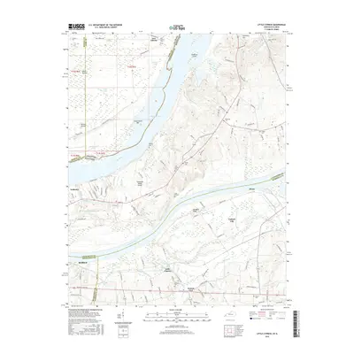
2016 Map of Little Cypress
USGS Topo · Published 2016About this map
Calvert City and Little Cypress anchor this landscape at the confluence of major river systems, where the Tennessee River meets the Ohio River. The geography is defined by complex bottomlands, featuring Towhead Island and Cottonwood Bar amidst a network of sloughs and creeks such as Goodwin Slough and Little Cypress Cr. The map documents a high density of small rural landmarks, including the Oak Grove Ch and New Liberty Ch, alongside numerous family burial grounds like Hurley Cem and Leonard Cem. Notable archaeological and topographical features such as Kincaid Mounds and the Tennessee Valley Divide provide context for the region's long history of human activity and natural drainage. This survey illustrates the modern transportation corridor, where the P & L RR and major roads intersect the historic river-based economy near Possum Trot and Altona.
Find a feature on this map
132 named features on this map. Tap any name to fly to it.
Don’t see what you’re looking for? This feature index may not catch every label — zoom into the map to look around manually.
Map Details
Editions of this 2016 Little Cypress Map
This is the sole edition of this map. No revisions or reprints were ever made.
Other maps of this area

1926 · Paducah
USGS Topo · 1:62,500

1929 · Smithland
USGS Topo · 1:62,500

1929 · Paducah
USGS Topo · 1:62,500

1936 · Paducah
USGS Topo · 1:24,000

1936 · Elva
USGS Topo · 1:24,000

1936 · Smithland
USGS Topo · 1:48,000

1936 · Symsonia
USGS Topo · 1:24,000

1936 · Benton
USGS Topo · 1:48,000
1936 · Calvert City
USGS Topo · 1:24,000

1936 · Little Cypress
USGS Topo · 1:24,000