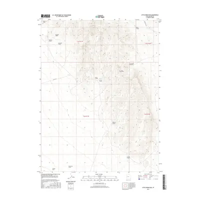
2017 Map of Little Drum Pass
USGS Topo · Published 2017About this map
Little Drum Mountains dominate this high-desert landscape in central Utah, where topographic detail reveals a complex network of drainage and elevation. The rugged terrain is defined by numerous named features such as Corral Canyon, Dennison Canyon, and Buckhorn Canyon, which funnel toward the open expanse of Whirlwind Valley. At the center of the sheet, the Little Drum Pass serves as a natural transition point through the range, while Black Point stands as a clear landmark to the northwest. The presence of Drum Mt Rd and Smelter Knoll Rd indicates the sparse but functional transportation routes used to navigate this arid environment. In the southern reaches, Swasey Wash provides evidence of the intermittent water flow patterns that have carved the floor of Whirlwind Valley over time.
Find a feature on this map
18 named features on this map. Tap any name to fly to it.
Don’t see what you’re looking for? This feature index may not catch every label — zoom into the map to look around manually.
Map Details
Editions of this 2017 Little Drum Pass Map
This is the sole edition of this map. No revisions or reprints were ever made.
Other maps of this area

1885 · Sevier Desert
USGS Topo · 1:250,000

1908 · Fish Springs
USGS Topo · 1:250,000

1910 · Fish Springs
USGS Topo · 1:250,000

1953 · Topaz Mtn
USGS Topo · 1:62,500

1953 · Delta
USGS Topo · 1:250,000

1958 · Delta
USGS Topo · 1:250,000

1962 · Delta
USGS Topo · 1:250,000

1971 · Clay Knoll
USGS Topo · 1:24,000

1971 · Drum Mts Well
USGS Topo · 1:24,000
1971 · Smelter Knolls West
USGS Topo · 1:24,000