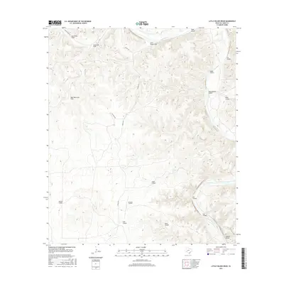
2016 Map of Little Fielder Draw
USGS Topo · Published 2016About this map
The Pecos River snakes through the high desert of Val Verde County, carving deep incisions into the plateau including Oppenheimer Canyon and Fox Canyon. This modern survey illustrates the persistent importance of water in a semi-arid landscape, evidenced by the distribution of remote water sources such as Tardy Spring, Cox Springs, and Everett Springs. Human activity in this portion of West Texas is defined by expansive ranching operations, linked by unpaved thoroughfares like Pandale Rd and Cash Ranch Rd. The presence of the 4M Ranch Airfield highlights the logistical challenges of managing this vast terrain, where named features such as Wolf Waterhole Draw and Little Fielder Draw reflect a long history of surface water management and navigation by early settlers and ranchers.
Find a feature on this map
25 named features on this map. Tap any name to fly to it.
Don’t see what you’re looking for? This feature index may not catch every label — zoom into the map to look around manually.
Map Details
Editions of this 2016 Little Fielder Draw Map
This is the sole edition of this map. No revisions or reprints were ever made.
Other maps of this area

1943 · Langtry
USGS Topo · 1:62,500

1943 · Shumla
USGS Topo · 1:62,500

1954 · Sonora
USGS Topo · 1:250,000

1958 · Sonora
USGS Topo · 1:250,000

1958 · Del Rio
USGS Topo · 1:250,000

1964 · Del Rio
USGS Topo · 1:250,000

1970 · Everett Canyon
USGS Topo · 1:24,000

1970 · Pandale
USGS Topo · 1:24,000

1970 · Little Fielder Draw
USGS Topo · 1:24,000
1970 · Divide Well Draw
USGS Topo · 1:24,000