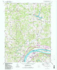
1994 Map of Little Hocking
USGS Topo · Published 1998About this map
The Ohio River defines the southern boundary of this landscape, where the Little Hocking River meets the larger waterway near the village of Little Hocking. The river valley at Washington Bottom is dominated by the long stretch of Blennerhassett Island, a site of significant local historical importance now protected as a Historic State Park. Inland, the terrain rises into the dissected ridges of Tick Ridge and Barnett Ridge, where small agricultural settlements like Dunbar and Napier are connected by narrow roads following the winding creek beds of Buffalo Run and Tupper Creek.
Find a feature on this map
67 named features on this map. Tap any name to fly to it.
Don’t see what you’re looking for? This feature index may not catch every label — zoom into the map to look around manually.
Map Details
Editions of this 1994 Little Hocking Map
This is the sole edition of this map. No revisions or reprints were ever made.
Other maps of this area

1902 · Parkersburg
USGS Topo · 1:62,500

1904 · Parkersburg
USGS Topo · 1:62,500

1904 · Chesterhill
USGS Topo · 1:62,500

1906 · Belleville
USGS Topo · 1:62,500

1906 · Chesterhill
USGS Topo · 1:62,500

1907 · Keno
USGS Topo · 1:62,500

1924 · Belleville
USGS Topo · 1:62,500

1926 · Belleville
USGS Topo · 1:62,500

1949 · Clarksburg
USGS Topo · 1:250,000

1956 · Clarksburg
USGS Topo · 1:250,000