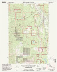
1997 Map of Little Hoodoo Mountain
USGS Topo · Published 2000About this map
Kootenai National Forest dominates this landscape in Lincoln County, where the industrial legacy of northwestern Montana is etched into the terrain. The network of waterways, including Libby Creek and Cherry Creek, once supported a flurry of mining activity, evidenced by the numerous prospects and established sites like the Herbert Mine and Double Mac Mine. Near the eastern edge, the settlements of White Haven and Pioneer Junction represent the residential growth around the city of Libby, while institutional markers like the Mc Grade Sch and the Heritage Museum anchor the local community history. The presence of the Libby Fisheries Station and multiple gaging stations along the mountain creeks reflects the ongoing management of the region's natural resources. From the heights of Little Hoodoo Mountain to the path of the Old Snowshoe Road, the map details a region transitioning from raw resource extraction to modern forest management and residential expansion.
Find a feature on this map
29 named features on this map. Tap any name to fly to it.
Don’t see what you’re looking for? This feature index may not catch every label — zoom into the map to look around manually.
Map Details
Editions of this 1997 Little Hoodoo Mountain Map
This is the sole edition of this map. No revisions or reprints were ever made.
Other maps of this area

1920 · Libby
USGS Topo · 1:125,000

1920 · Jennings
USGS Topo · 1:125,000

1930 · Libby
USGS Topo · 1:125,000

1932 · Libby
USGS Topo · 1:125,000

1935 · Thompson Lakes
USGS Topo · 1:96,000

1942 · Thompson Lakes
USGS Topo · 1:125,000

1957 · Kalispell
USGS Topo · 1:250,000

1960 · Kalispell
USGS Topo · 1:250,000

1961 · Kalispell
USGS Topo · 1:250,000

1963 · Scenery Mountain
USGS Topo · 1:24,000