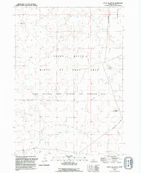
1992 Map of Little Joe Butte
USGS Topo · Published 1992About this map
Little Joe Butte and Wind Butte anchor this high desert plateau in southwestern Idaho, where the landscape is defined by vast tracts of public and military land. This 1990s survey illustrates a region largely dedicated to the Birds of Prey Area, a conservation zone protecting the sensitive habitat above the deep canyon of the Snake River. The map reveals the logistical footprint of the Idaho National Guard Training and Maneuver Area, which covers the southern half of the sheet. Surface hydrology is sparse in this arid environment, with the seasonal flow of Corder Creek and a single Gravel Pit serving as the primary interruptions to the natural topography. The geometric precision of range and township lines, such as T 2 S T 3 S, underscores the systematic division of this open range for federal management.
Find a feature on this map
10 named features on this map. Tap any name to fly to it.
Don’t see what you’re looking for? This feature index may not catch every label — zoom into the map to look around manually.
Map Details
Editions of this 1992 Little Joe Butte Map
This is the sole edition of this map. No revisions or reprints were ever made.
Other maps of this area

1892 · Mountain Home
USGS Topo · 1:125,000

1892 · Bisuka
USGS Topo · 1:125,000

1893 · Mountain Home
USGS Topo · 1:125,000

1894 · Bisuka
USGS Topo · 1:125,000

1947 · Jackass Butte
USGS Topo · 1:24,000

1947 · Dorsey Butte
USGS Topo · 1:24,000

1948 · Big Foot Butte
USGS Topo · 1:24,000

1948 · Jackass Butte
USGS Topo · 1:24,000

1948 · Dorsey Butte
USGS Topo · 1:24,000

1948 · Big Foot Butte
USGS Topo · 1:62,500