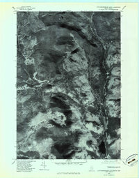
1977 Map of Little Kennebago Lake
USGS Topo · Published 1983About this map
White Cap Mountain and Snow Mountain dominate this high-altitude landscape of the Maine-Quebec borderlands during the late 1970s. This orthophotoquad provides a rare photographic perspective of the North Woods before modern satellite imagery became ubiquitous, revealing the dense forest cover and drainage patterns of the Kennebago River. The river winds through a valley defined by the Twin Mountains before reaching the dark waters of Little Kennebago Lake in the southern portion of the sheet. The absence of traditional cartographic symbols allows researchers to see the raw texture of the terrain, including the steep slopes of West Kennebago Mtn and the intricate network of logging paths or natural clearings that represent the only visible human impact on this wilderness area at the time of the photography.
Find a feature on this map
6 named features on this map. Tap any name to fly to it.
Don’t see what you’re looking for? This feature index may not catch every label — zoom into the map to look around manually.
Map Details
Editions of this 1977 Little Kennebago Lake Map
This is the sole edition of this map. No revisions or reprints were ever made.
Other maps of this area

1928 · Chain Lakes
USGS Topo · 1:48,000

1931 · Cupsuptic
USGS Topo · 1:48,000

1932 · Kennebago Lake
USGS Topo · 1:48,000

1932 · Arnold Pond
USGS Topo · 1:48,000

1932 · Chain Lakes
USGS Topo · 1:62,500

1934 · Cupsuptic
USGS Topo · 1:62,500

1935 · Kennebago Lake
USGS Topo · 1:62,500

1935 · Chain Lakes
USGS Topo · 1:62,500

1935 · Cupsuptic
USGS Topo · 1:62,500

1935 · Arnold Pond
USGS Topo · 1:62,500