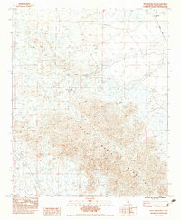
1983 Map of Little Maria Mountains
USGS Topo · Published 1983About this map
The Little Maria Mountains dominate this 1983 provisional survey of Riverside County, California. The landscape is defined by its arid geography, where drainage is primarily through a network of desert drainages including a large Dry Wash in the northeast. Human influence is minimal but present, evidenced by a single Prospect site and the winding path of Midland Road along the eastern edge. A rare source of water in this parched terrain is noted at Tank Spring, which sits at the base of the mountains. This edition was compiled from 1977 aerial photography and field-checked in 1978, capturing a period when this part of the desert remained largely untouched by large-scale development.
Find a feature on this map
5 named features on this map. Tap any name to fly to it.
Don’t see what you’re looking for? This feature index may not catch every label — zoom into the map to look around manually.
Map Details
Editions of this 1983 Little Maria Mountains Map
2 editions found
Other maps of this area

1942 · Blythe
USGS Topo · 1:250,000

1942 · Amboy
USGS Topo · 1:250,000

1943 · Amboy
USGS Topo · 1:250,000

1943 · Iron Mountains
USGS Topo · 1:62,500

1945 · Midland
USGS Topo · 1:62,500

1952 · Midland
USGS Topo · 1:62,500

1952 · Palen Mountains
USGS Topo · 1:62,500

1954 · Salton Sea
USGS Topo · 1:250,000

1954 · Needles
USGS Topo · 1:250,000

1954 · Rice
USGS Topo · 1:62,500