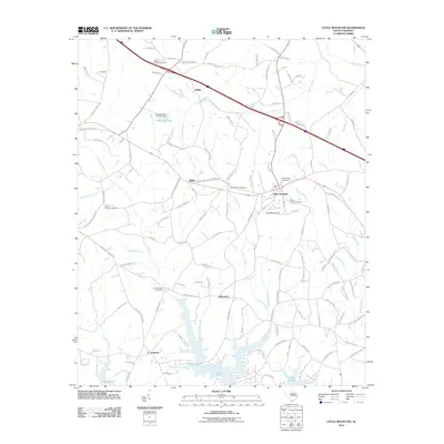
2011 Map of Little Mountain
USGS Topo · Published 2011About this map
Little Mountain stands as the central landmark in this South Carolina Piedmont landscape, surrounded by a high density of rural burial grounds and small communities. Genealogists will find a wealth of records preserved in the placement of Mount Hebron Cemetery, Mount Tabor Cemetery, and Mount Zion Cemetery, among several others that dot the road network. The settlement pattern is defined by historic clusters such as Slighs, Kibler, and Wheeland, connected by a web of local routes including Old Dutch Rd and Koon Trestle Rd. In the south, the terrain descends toward the northern reaches of Lake Murray, where numerous branches and creeks like Camping Creek and Stevens Creek drain into the reservoir. This map documents the rural character and family-linked landmarks of Newberry County just after the turn of the 21st century.
Find a feature on this map
112 named features on this map. Tap any name to fly to it.
Don’t see what you’re looking for? This feature index may not catch every label — zoom into the map to look around manually.
Map Details
Editions of this 2011 Little Mountain Map
This is the sole edition of this map. No revisions or reprints were ever made.
Other maps of this area

1904 · Columbia
USGS Topo · 1:125,000

1941 · Spartanburg
USGS Topo · 1:250,000

1953 · Spartanburg
USGS Topo · 1:250,000

1960 · Spartanburg
USGS Topo · 1:250,000

1963 · Spartanburg
USGS Topo · 1:250,000

1964 · Spartanburg
USGS Topo · 1:250,000

1968 · Newberry East
USGS Topo · 1:24,000

1969 · Pomaria
USGS Topo · 1:24,000
1969 · Jenkinsville
USGS Topo · 1:24,000
1970 · Prosperity
USGS Topo · 1:24,000